Article Archive
Thermographic Documentation of Roof and Building Damage Incurred During the 2004 Florida Hurricane Season

James Brady,President
Level-III Certified Thermographer
Brady Infrared Inspections, Inc.
935 Pine Castle Court
Stuart, FL 34996
772-288-9884
Warren C. Garber
Level-III Certified Thermographer
Brady Infrared Inspections, Inc.
935 Pine Castle Court
Stuart, FL 34996
772-288-9884
Abstract
History was made when four major hurricanes made landfall in Florida during August and September 2004. Winds in excess of 125 miles per hour accompanied by tornados and driving rains inflicted widespread and severe damage to roof and building systems. Infrared inspections were conducted for various types of insulated roofing systems using both long and short wave thermal imaging systems. Several structures were also thermographically inspected to document interior wall and ceiling damage caused by residual moisture and mold. This presentation provides thermal and visual documentation of inspections performed on several commercial and residential sites in the aftermath of these storms.
Introduction
I was very anxious to check into my hotel room and catch the weather forecast. Only two days prior, I had reluctantly flown from South Florida to Northern Alabama, knowing very well the business trip could be cut short. Before I arrived at the hotel, my suspicions were confirmed by a call from home. Hurricane Frances was brewing as a Category-4 hurricane in the Atlantic Ocean and was forecasted to make landfall somewhere along the southeast coast of Florida within four days.
Being the optimist that I am, I checked into my hotel room atop Cheehea Mountain State Park, the highest point (and one of most isolated points) in the State of Alabama. I reasoned that I could enjoy the evening there and arrange a flight to return home. Much to my surprise, the only reservation I could secure left Birmingham at 5:30 AM the next morning! This meant that I would have to leave the hotel at 1:30 AM to make the flight. Did I mention the part about being in a very isolated point? I suddenly felt a sense of urgency to get home. After an hour of hand wringing and total disbelief from the front desk, I checked out and drove to a hotel close to the airport.
While driving that night, I could not help but think of my trip to Punta Gorda, FL just three weeks earlier to deliver supplies to relatives who had suffered a direct hit from Hurricane Charley. The destruction and desperation of that community was sobering. Now we were possibly facing the same fate.
Little did anyone realize that three more hurricanes would make their presence known in the State of Florida – by season’s end a total of four. Incredibly, two hurricanes, Frances and Jeanne, made landfall on my home town of Stuart within a three week period. The other two storms struck the Southwest Coast and Panhandle area of the state. These storms left paths of destruction, some of which intersected three times in central Florida.
The damage inflicted included residential, commercial, and public works. Some parts of the state were without power for weeks. Insurance adjusters and outside utility workers came into the state by the hundreds. The main concern was to return people to their homes, so insurance adjusters concentrated on the residential damage and were slow to move on the commercial damage. With thermography, we could help the business owners evaluate moisture damage to roofs and interior spaces quickly and graphically.
This presentation is a documentary of the challenges my thermography business faced in the aftermath of two major hurricanes that hit my hometown of Stuart, Florida. The outcome of various projects that resulted from these storms, including roof and building systems, will be presented.
Hurricanes
A North Atlantic Basin formed hurricane is a tropical cyclone of counter-clockwise rotation with heavy rain and wind in excess of 74 miles per hour (mph). The ingredients for a tropical cyclone include a pre-existing weather disturbance, warm tropical oceans, moisture, and relatively light winds aloft. If the right conditions persist long enough, they can combine to produce the violent winds, incredible waves, torrential rains, and floods associated with this phenomenon.
A designated scale, the Safffir-Simpson Hurricane Scale, has been adopted by the National Oceanic and Atmospheric Administration to catagorize hurricane strength and potential damage.
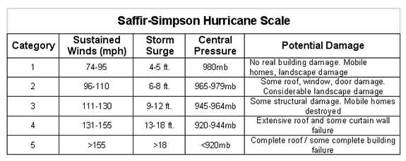
Since 1995, only a few hurricanes, Opal in 1995, Fran in 1996, and Brett in 1999, have come ashore in the U.S. as major hurricanes. Given this number, it is easy to see how unusual but impressive it was that four major hurricanes made landfall in Florida in 2004 within a six week period! The last time so many storms struck the same state in one season was 1886, when Texas also took four direct hits from hurricanes.
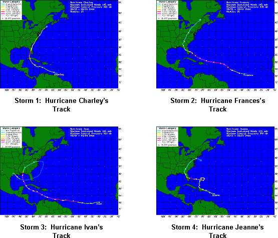
The first storm to hit was Hurricane Charley who slammed into Punta Gorda, about 70 miles south of Tampa, with winds of 145 miles per hour on August 13, 2004. Hurricane Frances, a category two hurricane with winds between 90 and 115 mph, came next, striking the Stuart area on Labor Day weekend. Charley was a large, slow moving storm that took nearly two days to pass.
Wasting no time, Hurricane Ivan made landfall in the Pensacola area on September 16th with 130 mph sustained winds. At one point, Ivan was one of the most fearsome storms on record, packing winds of 165 miles per hour as it rolled across the Caribbean. Ivan lost strength before making landfall. As if that were not enough, Hurricane Jeanne, who had been wandering aimlessly out in the Atlantic, made a complete circle and hit on September 26 as a category three storm. Jeanne made landfall on Hutchinson Island, just east of Stuart, Florida. This is only about two miles from Sewall’s Point, where Hurricane Frances struck Florida just three weeks earlier.
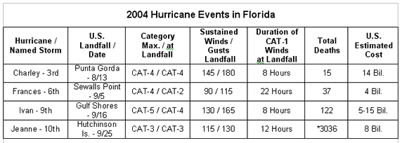
* Mostly due to widespread flooding and mudslides in northern mountainous region of HaitiSource of information: http://en.Wikipedia.org
Heavy and strong weather associated with the interior of hurricanes approaches in weather bands lasting from a few to several hours. A weather band may bring heightened wind and rain for up to 20 minutes before subsiding to sustained wind conditions. It is also a general rule that the strongest weather occurs in the north right quadrant of the storm because it combines the speed of the storm’s winds with the force of its forward motion. This was definitely evident in the areas north of Stuart, namely Port St. Lucie, Ft. Pierce, and Vero Beach, where damage was at its worst.
Hurricane Frances
I arrived back in Stuart Wednesday afternoon, September 1st, to learn the updated forecast had Hurricane Frances making landfall on the Treasure Coast, with the City of Stuart lying directly in the center of her path. This left one and one-half days to prepare for a hit from a potential Category 4 storm. The old phrase “so much to do and so little time” really hit home as I scrambled to secure my house and office.
First the office! All of my important business documents, computers and camera equipment were stored in large plastic containers and plastic bags. The main computer system was completely backed up on CD. All of these items were brought with me. Everything left behind was pulled away from the windows and covered with plastic sheets.
At the house, plywood was secured over every window and door. Patio and yard equipment and toys were brought inside the garage and the pool water level was lowered as much as possible to accommodate the expected heavy rains. Needless to say, everything on my list was completed by Thursday evening.
We learned on Thursday that the storm track had been narrowed to between Jupiter and Vero Beach, with Stuart located equidistant between the two. My wife and I discussed our options and thought it best to evacuate, with our two young boys, to my parents house in Ft. Lauderdale.
The large size of Frances combined with an eye over 80 miles wide slowed her forward progress and arrival onto land. The storm was also weakening as it remained virtually motionless off-shore. Hurricane conditions were felt in the Stuart area as early as Saturday afternoon, however, the eye did not make landfall at Sewalls Point (town directly east of Stuart) until early Sunday morning at 1:30 AM. In all, hurricane winds in excess of 74 mph blasted the Treasure Coast for more than 22 hours, and for most of that time winds were near 90 mph. Wind gusts as high as 115 mph were felt for over six hours as the eye crawled over our area. Neighbors who stayed said that the wind howled like a train and they felt the exterior walls of their homes move with the wind gusts during the most intense parts of the storm. My wife and I watched the events unfold on the local news channels and wondered what was in store for us upon our return home.
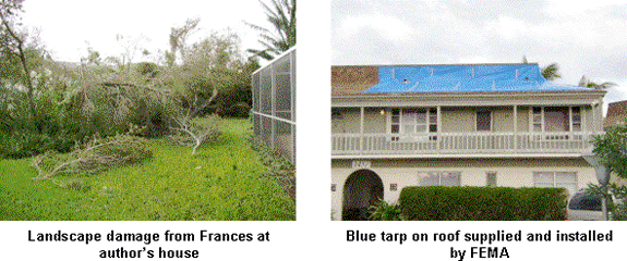
I was able to make my way back to our house early Monday morning. We lost most of our landscaping, but thankfully had only minor structural damage to the roof and screen patio enclosure. I spent the better part of the next five days cutting and hauling yard debris to the curb. Electricity was absent in our neighborhood for nearly ten days. I was fortunate to be able to commute back and forth from Ft. Lauderdale every day where the luxuries of life were still intact. In the days following the storm, I brought ice, gasoline and other necessities requested by our neighbors. By the third day, I was able to obtain a portable generator that was shared between four households to power refrigerators and some lighting.
Damage throughout the area was extensive. Debris started to pile up everywhere. Traffic signals were out at major intersections. Lines to receive ice, water, and limited food were five to eight hours long. It was also evident from the number of roofing contractors working about town that many commercial buildings suffered extensive roof damage. Furthermore, many residential homes suffered water intrusion from roof systems that had been breached.
During the week that followed Frances, helicopters operated by FEMA, the National Guard, and the Coast Guard flew non-stop to assess damage and patrol for crime. FEMA had a free program whereby they provided and installed blue tarps to residential homes that suffered roof damage.
From the time of my sudden departure from Northern Alabama until general clean-up of our house was complete and power restored, it had been almost two weeks since I was involved with my business. I had made preliminary calls to clients with whom we had scheduled electrical inspections, but they too had been adversely affected by the storm and unfortunately postponed their commitments – indefinitely. To make matters worse, a contract we were working on in Alabama and Mississippi was also postponed to allow Hurricane Ivan, a Category 3 storm to pass through the Panhandle of Florida.
My business associate, who lives in Jacksonville, FL, some 300 miles north of Stuart, suffered extensive landscape damage from a spree of tornados that spawned from Frances. This, combined with the birth of his first child two weeks earlier, put his involvement in the business on hold during this time.
The end result was that nearly six weeks of backlogged work was lost with very few prospects in the immediate future. For a small company in its third year of business, this is not an enviable position.
The First Turn Around
Due to all of the roof and building damage suffered from the storm, I knew that thermography opportunities existed. It was just a matter of making contacts and finding the jobs. Within ten days of Frances, work slowly filtered in from both residential and commercial customers.
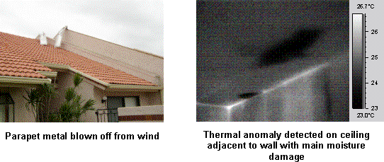
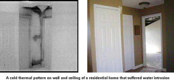
Our first inspection was a residential townhouse that lost a portion of a parapet wall cap and suffered interior water damage. Upon arriving, the A/C thermostat was lowered to cool the room and fans were set up to promote evaporation. A scan of the interior walls and ceiling identified “cold” thermal anomalies interpreted to be water damage. The wall where water had traveled showed a thermal pattern starting from the bottom of the wall and traveling up. Much to my surprise, thermal cold spots were detected several feet in from the primary wall where water had traveled into the room. Both thermal and visual photographs were saved and presented to the client who was working with a mold and interior damage specialist.
Our next group of jobs came from a local property management company that I had made contact with over a year earlier. At that time, they expressed interested in roof moisture surveys but never committed to any work. Surprisingly, they had four commercial buildings that had suffered major roof damage and needed documentation of the damage to present to their insurance company.
About the same time, Martin County General Services Department hired us to scan the county library which suffered major damage from roof tiles that blew off. Again, this was a client that I had contacted nearly three years earlier but never worked for until now. They had a roofing contractor on hold and wanted to determine if the roof was worth repairing.
Wasting no time, my associate and I geared up to perform walk-on roof surveys. We had a FLIR PM695 and a FLIR E2 available, both long-wave microbolometer cameras. It was decided that we would not perform destructive testing to verify thermal anomalies because both of these customers had roofing contractors following behind us to perform this task.
One of the biggest obstacles we faced was the weather. South Florida was still in a summer weather pattern; hot humid days and warm humid nights with locally heavy rains. Delta temperatures between daytime high and nighttime lows barely approached 10 F degrees. More problematic was the fact that nighttime cooling was very slow, especially the fist several hours after sunset, which delayed the ideal imaging window.
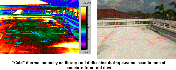
Our first survey commenced at the county library; a single-ply roof system that had suffered multiple punctures from flying roof tiles. Within forty minutes of working, a light rain began to fall. Prior to the rain we found one thermal anomaly along the parapet wall, but not in the vicinity of the punctures. We spent a good deal of that time flagging mechanical damage on the roof.
We then moved across town to scan a Winn Dixie Shopping Center roof, only to find that ten minutes before our arrival a torrential rain shower had occurred. Not to be defeated, we moved on to our third roof located approximately 20 minutes away.
This was a load master roof system with a modified bitumen cap sheet. A large portion of the roof was lying on the ground on one side of the building. Evidently, wind had breached the parapet wall flashing and uplifted the roof. The torn section of roof had already been dried in when we arrived. We found a weak but defined thermal anomaly that spanned the tie-in boundary between the existing and temporary roof. Several other small anomalies were also located within the existing roof field. We were able to complete this roof and one other that night before rain finally settled in.
Discussing the chain of events that evening, we decided to revisit the library roof the following morning. It was quite possible we could use the solar loading of the roof to our advantage and capture a “scan window”. As it turned out, we identified a large thermal anomaly located among several punctures. We also delineated a wet section of roof, not correlated to a thermal anomaly but felt under foot, in the area of punctures. It was possible that the water infiltration in this area was a direct result of the recent damage and that the iso-board insulation did not have sufficient time to absorb the moisture. Rather, water was sitting between the insulation panels and directly on the metal deck. A report was generated and delivered to the client that afternoon.
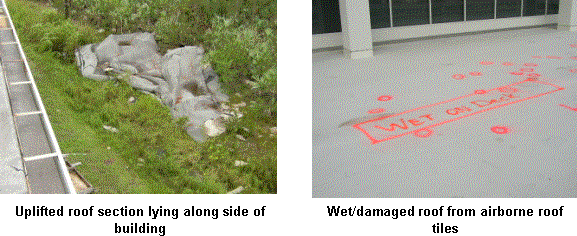
That evening we returned to the Winn Dixie roof. The main roof was a single-ply roof system. Examining a section of roof removed from the storm, we discovered that two separate recovery roof systems had been installed over the original gravel built-up roof; a modified bitumen followed by the single-ply roof. Nearly 80 percent of the entire roof showed signs of moisture damage. Interestingly, only a small portion of this roof had lifted off during the storm but thermal anomalies were widespread. Damage was also documented of missing wall flashings and debris that punctured the roof membrane.
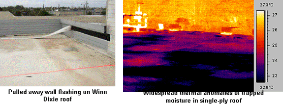
Two additional roofs were scanned that evening. One of them was a smooth built-up roof with lightweight concrete insulation on a metal deck. A large portion of the roof had been lifted away and repaired with two-ply roof felts as a temporary dry-in. We documented widespread thermal anomalies throughout this roof as well. The lightweight concrete insulation provided very irregular, blotchy thermal patterns.
Most of the roofs we scanned that week had portions that catastrophically lifted away or were mechanically damaged from flying tiles and other debris. Broken and missing roof tiles and lifted parapet cap metal was common. Roof types included single-ply PVC, gravel built-up, smooth built-up, and modified bitumen systems. Insulation types included various combinations of lightweight concrete, dens-deck, perlite, iso-foam board and fiberboard. All of these roofs were inspected using a long-wave microbolometer imager. Surprisingly, we were able to produce very good results given the weather conditions we faced. Furthermore, providing digital photography of mechanical and physical damage was as important a service as the moisture surveys.
With so much roof damage, it was essential to keep in mind that our underlying purpose was to provide thermal documentation of anomalies interpreted to be trapped moisture. Without historic moisture survey information, correlating interpreted moisture with the actual storm event was impossible to make with any certainty. Our reports made no reference to these events. Interpretation and negotiation of timing and impact of damage was left between the client and their insurance carrier.
Hurricane Jeanne
While performing post-Hurricane Frances inspections, we watched Hurricane Ivan slowly make its way up the Gulf of Mexico and hit the Pensacola area in the Florida Panhandle. We were also keeping an eye on a wandering storm in the Atlantic, Hurricane Jeanne. It appeared that Jeanne was well on her way out in the Atlantic when she suddenly made a U-turn and began heading due west.
Denial, followed by anger and finally urgency was felt throughout South Florida while bracing for a second hurricane. Unlike Frances, Jeanne was moving faster and provided only three days of notice before making landfall on the Stuart area. Jeanne was not showing a gradual weakening like Frances and therefore was expected to be stronger at landfall.
The same household and office preparations had to be made. My family also evacuated to my parents house in Ft. Lauderdale once again and watched live coverage as Jeanne made landfall on Hutchinson Island, only two miles due east of Stuart. Based on what we saw on television, my wife and I were expecting major damage to our house. Thankfully, we only suffered screen damage to our patio enclosure and several roof shingles were torn off.
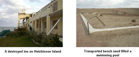
Although Hurricane Jeanne was stronger than Frances, she moved much faster through the area; less than six hours of intense 100 mph winds were felt in our neighborhood with gusts as high as 130 mph. This time around, landscape damage was not as severe since most of the vulnerable plants and trees were removed by Frances. Structural damage however, was much worse. Commercial building walls were knocked down. Homes on Hutchinson Island, a barrier island just east of Stuart, were flooded and destroyed. Sand from the beaches was transported hundreds of feet inland, filling condominium pools and forming impressive sand dunes that choked beach parking lots and prevented passage to most public beaches. The island was inaccessible for nearly 5 days to allow flood waters to subside. Even then, residents were walking two miles to reach their homes.
The Second Turn Around
My post-hurricane clean-up from Jeanne was significantly easier than what followed Frances. Power in our neighborhood was restored within three to five days. The lack of trees falling into power lines helped this cause. I was able to pick up a few more jobs about the time power was restored.
One inspection was a residential home owned by my neighbor’s daughter. The house suffered major roof damage and had nearly 2-inches of standing water throughout.
A FLIR ThermaCAM PM390 short-wave camera was used to conduct the inspection. Cold anomalies were documented along baseboards, in ceiling / wall corners, on walls and on the bottom portion of ceiling beams. Visible mold was documented along a few of the baseboards and an inspection, done two days later, by a company specializing in moisture/mold showed extensive mold growth behind many walls. It was interesting to note that mold development was much more extensive than what our findings showed. This could be explained, in part, by the fact that we could not create a high delta-temperature inside the house. Since the power was still out, we could not use the air conditioning system and were forced to use a window mount A/C unit and fans powered by a portable generator to change the interior environment.
Another job involved a roof scan for the hospital in Vero Beach, about thirty-five miles north of Stuart. Traveling to and from this job, especially the return trip home at 2:00 AM, proved to be very interesting. An 8:30 PM curfew was in place throughout the county for several days following the storm. The only sure way to successfully pass road blocks set up every two to three miles was to have a work permit issued by your employer. Thankfully we had the foresight to obtain a letter from the facility’s director explaining the purpose of our work. We saw several people, who obviously lacked permits, being arrested while we passed though the road blocks.
During one of our evenings on the hospital roof, we had the rare opportunity to see a substation transformer undergo a ground fault that proceeded to light up the evening sky. It lasted nearly a minute and started with pulses of light, followed by a long continuous glow and then a few sporadic flashes. Apparently, the utility company tried to power up a portion of Hutchinson Island and experienced a ground fault that traveled back to the substation. Needless to say, a thermal imager was not needed to determine they had a problem.
Thermal anomalies documented on this roof could not be directly correlated to visible damage we saw. The roof system was a gravel built-up roof with lightweight concrete insulation. Both a FLIR ThermaCAM PM 390 and PM 695 were used for scanning. This job presented a great opportunity to have both long- and short-wave imagers side-by-side to compare imaging quality. Regional, amorphous thermal patterns were documented on several areas of the roof. Fortunately, most of our scanning was done from higher roofs onto lower roofs, helping to reduce the thermal halo problems brought on by low viewing angle of incidence inherent to walk-on surveys. We did not notice a significant difference in image resolution between the two cameras while imaging “down” onto lower roofs.
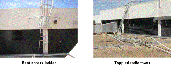
Visible damage on this roof included displaced gravel in the form of drifts against parapet walls, missing roof drains on the fifth floor roof, a bent access ladder, a toppled radio tower, downspouts torn from walls, and a lightning rod impaled into the roof.
Another project involved acceptance testing of a newly installed high density, sprayed on poly-foam roof system on a four story condominium located on the beach in West Palm Beach. A large portion of the main fourth floor roof was torn off during Hurricane Frances and amazingly, was replaced prior to Jeanne. The penthouse units directly beneath this roof had water intrusion damage.
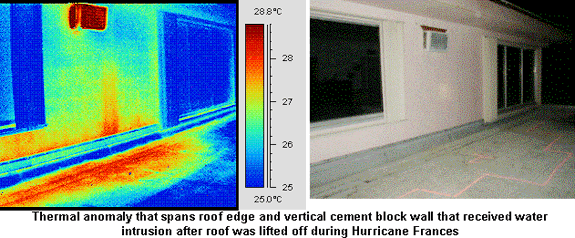
The new roof was absent of thermal anomalies, however, a thermal anomaly was documented on a lower level roof adjacent to one of the penthouse units. The anomaly occurred adjacent to and partially up an exterior cement block wall. A moisture meter was used to verify the presence of moisture in the wall. It is believed that water had entered the CB wall during the storm and traveled vertically down and entered the roof system along a failing wall flashing.
On still another project, we were asked to perform a roof scan on two commercial retail stores that had been affected by Hurricane Charley. As fate would have it, a rain storm cropped up as my associate made his way into the Tampa area, after driving four hours from Jacksonville in beautiful weather. A visual inspection verified standing water on the roof so the scan was called off for the evening.
Scheduling issues prompted my associate to visit the second roof the following day to see if a daytime scan could be performed. A FLIR ThermaCAM PM 390 short-wave and a FLIR E2 long-wave camera were used to conduct this inspection. The high emissivity of the EPDM roof system combined with the lack of roof-top equipment and structures that would cause thermal interference and shadows helped to produce excellent scanning results. Two distinct thermal anomalies were traced out.
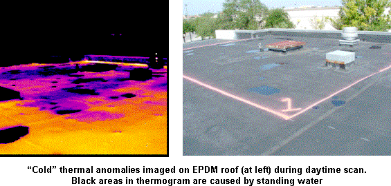
Both short- and long-wave imagers gave workable results throughout the morning. That evening, the first roof that was rained out the previous evening was scanned. This gravel built-up roof proved to be more of a challenge. The roof was covered with air handling units and exhaust fans, many of which had been moved to various locations around the roof leaving patches and penetrations. Better imaging results were had using the FLIR ThermaCAM PM390 on this roof.
Final Comments
The hurricane season of 2004 was unique in that it brought widespread and major destruction to the entire State of Florida in a very short amount of time. Brady Infrared Inspections, Inc. was faced with the unique challenge of replacing several weeks of canceled business in the aftermath of these storms. Main-stay electrical inspection work fell by the wayside as the demand for roof and building system thermography grew. Being able to recognize and meet these demands was critical in stabilizing our business though this uncertain time.
Although less than ideal scanning conditions existed for most of the projects we conducted, developing creative approaches to overcome these obstacles lead to excellent results. We also found that both long-wave and short-wave imagers are equally suited for conducting most roof surveys. However, having the luxury to choose between cameras for a particular roof or building system survey increases the likelihood of success.
Looking back on the new clients we worked for after the storms, it is evident that persistent marketing and maintaining customer relationships cannot be stressed enough. Several of the jobs conducted were first time projects for clients that were initially contacted three years earlier. By maintaining periodic contact with these customers, a trust was established that made it very easy to sell our services to them.
Finally, a thermography business can only benefit by having a diverse list of services available. If electrical inspections had been our only service, things may have been much different for the business after the storms. Our ability to offer roof and building system surveys lead to new client relationships that may in turn develop into other thermography opportunities; perhaps even electrical scans.
Advertisement

